
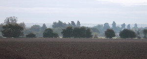
The village of Broomfield lies some two and a half miles to the north of the county town of Chelmsford, Essex. The parish covers 747 hectares, the bulk of which is cultivated land, mostly for growing crops but also meadow. This land is crossed by a network of footpaths, providing pleasant walks and views across the countryside. The northern and southern boundaries of the parish are familiar as they are well-signed on Main Road. Less well-known are the eastern and western limits.
To the east, the parish stretches across the River Chelmer and its associated flood plain, beyond Essex Regiment Way towards Beaulieu Park and New Hall. To the north- west, it stretches almost to the Pig and Whistle pub on Chignall Road. The main settlement areas lie alongside Main Road (the B1008) which runs north/south through the Parish. The settlement covers 55 hectares and is home to over 4,000 people. The River Chelmer is the lowest point of the parish, with the land rising to about 50 metres in the east and 60 metres in the west. The highest point in the settlement area is occupied by the Parish Church of St Mary with St Leonard, and the conservation area of Church Green.
In a community-wide consultation exercise undertaken in the development of the Broomfield Parish Plan, published in 2005, over 90% of respondents said that its tranquillity, open aspects, wildlife, opportunities for recreation, and the natural break between Broomfield and Chelmsford were important contributors to its attractiveness as a place to live.
While Broomfield is not without its problems, such as the lack of certain core services and concerns about traffic, lack of parking provision, low-level crime, and proposals for hundreds of new homes within the parish, our strong sense of community is revealed by the statistic that 94% of residents would like to stay here. Our local clubs and organisations are well-supported, and people like the sense of identity that comes from living in a smaller community.
Broomfield has seen many changes in its history, which predates Roman times. It has more or less successfully absorbed a wide variety of domestic and commercial architectural styles over the centuries. In some areas – in particular those in the Conservation Area surrounding Church Green, as well as Angel Green and Parsonage Green – it has successfully retained its attractive village character.
Broomfield also contains the Borough of Chelmsford’s single biggest employer, Broomfield Hospital, as well as one of Chelmsford’s largest secondary schools, both of which are built to an entirely different scale. Both generate considerable traffic, particularly at rush hour, and in the case of the Hospital, ambulances at all times of the day and night. There are also some commercial sites on Main Road which, although they provide useful amenities, are not in character with surrounding homes and other properties.
In June 2010, Chelmsford Borough Council submitted its North Chelmsford Area Action Plan (NCAAP) to the government. The NCAAP allocates up to 800 dwellings in North-West Chelmsford and Broomfield for the period up to 2021. These are divided between four locations in the Parish, two adjoining the current settlement area (North of Hospital Approach and around Broomfield Place) and two adjoining North-West Chelmsford (North of Essex Avenue and North of Copperfield Road). In addition, the eastern part of the Parish, East of Essex Regiment Way, will be subsumed within the North-East Springfield neighbourhoods, the much larger development within the NCAAP.